The enclosed picture is an old ordnance survey map (year unknown) Which clearly shows a burial ground in the area concerned. In fact it shows two burial grounds (disused) alongside each other, (I have marked these with a cross). The grave yard of St Oswalds is also shown.
In the book 'The Iron Church' a history of St Georges church, there is an item related to the Irish immigrants and the city council having to hire thousands of special policemen and the government sending 2;000 troops to Liverpool.
Make of this what you will!
Hi Samp, the two "X's marks the spots" are burial grounds for the nuns and old priests etc. The mass graves where found on your map "under" Percival St and the houses below it, this is where the new school now stands.
Martin
Attempting to find some information regarding burials around the Old Swan area. Had an ancestor who died Rock St, Old Swan in 1913. Would anyone have an idea to the closest cemetery to Old Swan the person may have been buried at?
It's also possible that they may be buried in a church graveyard.
Never put anyone on a pedestal... THEY'LL LOOK DOWN ON YOU!
Hi Samp, the two "X's marks the spots" are burial grounds for the nuns and old priests etc. The mass graves where found on your map "under" Percival St and the houses below it, this is where the new school now stands.
Martin
Thanks for the info, Martin. I though the school was built where I indicated, I stand corrected.
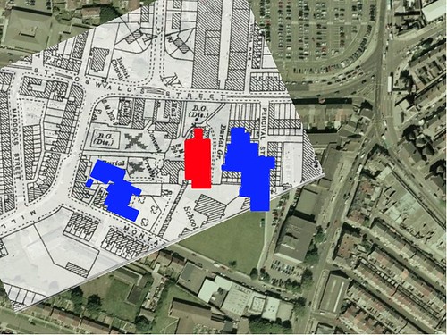
Looking at the Undates OS Map, my 1830s tithe map and a modern map of the area (using Google Earth) to layer them I have come up with this rather startling result.
Here is the modern map, St Oswalds Church in Red. St Oswalds School in Blue.
Now with the undated OS map, probably late Victorian or early 20th C.
Now the 1830s tithe map. Harder to make everything line up on this one...
As you can see, there have been buildings next to the church since the 1830s. So there is zero chance of the 'mass grave' being part of a Potato Famine related incident.
I've got some more thoughts on this... i'll post them up later!
Fortinian, your OS map must be after 1906 as I have the 1906 version and only theleft half of Maddocks St exists on my 1906 map, whereas as it's complete on yours,
Martin
Looking at the Undates OS Map, my 1830s tithe map and a modern map of the area (using Google Earth) to layer them I have come up with this rather startling result.
Here is the modern map, St Oswalds Church in Red. St Oswalds School in Blue.
Now with the undated OS map, probably late Victorian or early 20th C.
Now the 1830s tithe map. Harder to make everything line up on this one...
As you can see, there have been buildings next to the church since the 1830s. So there is zero chance of the 'mass grave' being part of a Potato Famine related incident.
I've got some more thoughts on this... i'll post them up later!
I've been scratching my head reading through these thread's, because I'm almost certain that the mass grave was at the junction of MILL LANE and MONTAGUE ROAD, which is the site of St.Oswalds "new" junior school. The area highlighted blue on the above maps is the infant's school & nursery which were built later. I can remember the work going on at the time, because I went to the "old school" at that time which was on Montague road, directly behind the church.
The "new" junior school play-ground & infant school playing field is where the old school stood.
Pete E. I can guarantee the Mass Graves were found on the map highlighted in Blue, not the "new" school on Montague road.
I also went to St Oswalds and remember them finding the graves on St. Oswalds St side. Martin
Pete E, you are right to be scratching your head... but I have a sneaking suspicion you are right, theat we are looking at the wrong school.
I don't mean to pour doubt on your truthfulness hmtmaj, but childhood memory is a notoriously fickle thing.
If we look at the 1981 Ben Travers article, previously posted there are a few clues that support Pete E...
1. The lead photo seems to show the church some distance from the school... behind quite a lot of trees. Now if you look on the modern googlemap below, you can see where the 'BLUE' school is there are few trees that side of the church. On the other side, where Pete E is speaking about there are many trees and I imagine would give a photo like the one in the article.
But of course, trees can be cut down... so here is some more evidence.
2. Father Patrick James McCartney, parish priest in 1973 is said to have noticed the burials "at the bottom of the garden". We know that the church was surrounded by a graveyard (hardly going to be called a 'garden') and the area where the BLUE school is was already built on... this leads to the conclusion that the priest is talking about the garden to the presbetry, on the rear left hand side of the church and with an extensive garden over the old "Burial Ground (dis.)".
3. The article then goes on to say "three feet beneath St Oswalds scrubland". Hardly what you would call the land where 'Percival Street' was. Scrubland is a weird phrase to use really, on the post-1906 OS map there is an area of trees to the south of the church/presbetry... but would that be scrubland? And even stranger... there was no burial ground marked there...
I suspect that the reporter was getting confused between scrub and garden but still...
The final proof... for me at least is what happens when I map the new Junior School site onto the post-1906 OS map.
The school building covers half of the disused burial ground.
I've convinced myself... but if anyone has any other ideas or can see flaws in my argument i'd love to hear them.


 Reply With Quote


Bookmarks