Ullet Road plaques: Junction with Belvidere Road (on Belvedere School wall), junction with Aigburth Drive (on and old gate post). Both are at floor level.


Ullet Road plaques: Junction with Belvidere Road (on Belvedere School wall), junction with Aigburth Drive (on and old gate post). Both are at floor level.
This stone is at the junctions of Breck Road/Lower Breck Road/Townsend Lane.
This appears to be different to all the others, as it is dated...1817. A few letters can still be seen on two sides. It is visible from a satellite as a small dot at the left of this grassy triangle:
http://maps.google.com/maps?f=q&hl=e...=19&iwloc=addr

spotted this by accident on Edge Lane Drive. I'd stopped to take a photo of summat and my camera started to play up. as I was replacing batteries I caught sight of this in the kerb.
I'm assuming it was originally on a wall (as it says erected) and was moved down when the road was widened perhaps?
Proud Scouser, with a dabbling of Welsh and Irish.
bore yourself silly at my Flickr page...anorak central!
It could be in the original position.Originally Posted by quincyg

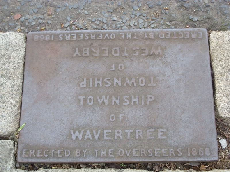
This side: West Derby.
That side: Wavertree.
The name "Edge Lane" denotes a boundary.
Great images, marky and quincyg!
I think these "remainders" of past times are endlessly interesting.
Chris
Christopher T. George
Editor, Ripperologist
Editor, Loch Raven Review
http://christophertgeorge.blogspot.com/
Chris on Flickr and on MySpace
Not many people know about this stone set in the tarmac of Castle St.
It marks the boundary of the old Liverpool Fairs in the middle ages. You weren`t able to be arrested if you had taken something in the fair and not paid for it till you had crossed this perimeter.
I took this yesterday just as it started raining
Last edited by gregs dad; 05-12-2008 at 07:28 PM.
THE BEST VITAMIN FOR MAKING FRIENDS ? B.1
My Flickr site: www.flickr.com/photos/exacta2a/
http://flickrhivemind.net/User/exacta2a
This is the plaque denoting the stones on the NatWest bank wall in Castle St
THE BEST VITAMIN FOR MAKING FRIENDS ? B.1
My Flickr site: www.flickr.com/photos/exacta2a/
http://flickrhivemind.net/User/exacta2a
Nice work, gregs dad. I photographed the stone and the plaque when I was in Liverpool in May (see below) -- and I had earlier photographed it in b&w in the Sixties when I photographed a number of the city's historic sites and curiosities (hope to scan some of those pics in shortly). Look at the color changes (rain and sun related I guess) in your version of the stone!Actually the street surface of Castle Street does not show in my version, only the cement surrounding the old Sanctuary Stone.

Christopher T. George
Editor, Ripperologist
Editor, Loch Raven Review
http://christophertgeorge.blogspot.com/
Chris on Flickr and on MySpace
A happy accident.I agree with Philip...the boundary line is clearly between the two words of "township",so it makes sense for the stone to be meant to be laid flat. Not too far away are some odd bollards dated 18xx,also erected by these 'overseers',which have always puzzled me as to their purpose. They look like the types the ferries tie their mooring ropes around,but TJ's car park is a long way from the river.
.
Dave.
Hi Quincy and Dave
I would interpret it that the plate was always set in the ground and not on a wall, and that it therefore actually marked the physical boundary between the two areas. Seeing as the top part of the plate is upside down and I was puzzling to read it, I took a few moments to realize it is actually "West Derby" as the actually presentation "WESTDERBY" looked strange to me... "Westerbery" or something. Ha!")
Chris
Christopher T. George
Editor, Ripperologist
Editor, Loch Raven Review
http://christophertgeorge.blogspot.com/
Chris on Flickr and on MySpace
Found this one down towards Otterspool, Riversdale Road Aigburth.

Become A Supporter ?
Donate Via PayPal

That's interesting Kev. I'll have to investigate.
Last edited by Kev Keegan; 08-28-2008 at 07:52 PM.
Could be a bench mark stone where the metal OS bench marker has been "liberated" I notice on the 1907 Garston map that there's such a BM on the right hand side just beyond the cricket ground as you approach Otterspool. Was this where you saw the stone Kev?
If walking from the cricket club, its on the left [cricket club side if facing the river]
Become A Supporter ?
Donate Via PayPal
Spotted a pair of these West Derby markers being installed as bollards at the entrance to a hotel in Anfield Rd. Clearly they have been taken from somewhere else.Quite a disgraceful disregard for Liverpool's heritage in a so called regeneration area
 Posting Permissions

 Reply With Quote


Bookmarks