
That?s interesting Cad, the wooden carvings from around the alter are also to be seen in the church in Churchtown near Southport.Originally Posted by Cadfael


That?s interesting Cad, the wooden carvings from around the alter are also to be seen in the church in Churchtown near Southport.
It's all a bit strange when it comes to the demolition of churches. I know for a fact that the bells from this church went to St Helen's because church bell's always can be found going in to a new home but you wonder what happens to the rest of the stuff once a church is demolished.
As with St Luke's, there were actually a few bells saved from the tower after the fire and the Corporation decided to have them sold for scrap in the 60's!
When was it demolished? Funny how cemetaries were/are in the centre of towns. The Church in the centre of St Helens shopping area has a cemetary and regulary remains are unearthed by workmen. Also, Palmyra square/park in the centre of Warrington is actually a cemetary with many still buried there.
Brilliant pics and info dazza. I wonder why the church was slightly offset like that, I wonder if Church st originally followed that line but then the church wall is set along the lines of the street as it is now isn't it.
1919 from my source though some say up till 1923. Another sad loss of a church even though it was the 'Pro Cathedral'.
Another ebay...St. Peter's 1916 water colour
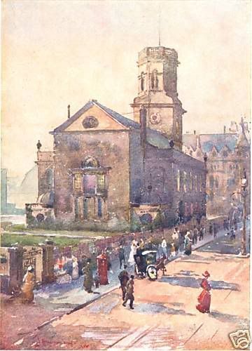
Fantastic pic's and detail Dazza,but I'm pretty sure that I read Church st. was, widened,after the church's demolition,and possibly,this would affect the position of the "altar" cross?
Thanks everyone for your posts, and thanks Ged and wsteve for your questions. Hopefully I'll be able to answer you both below.
Questions raised:
1. Where was the original building line of Church Street, as the street today is much wider?
2. St. Peter's church is set at a different angle to the street. Did the early buildings following this line, or the street line?
3. Where is current position of St Peter's Altar today, and does the Maltese cross sit directly over it, [city myth]?
OK, I think I've managed to answer all of them below. Image descriptions are given below each image.
Image 1 - 4 Maps of Church Street ^ 1725, 1765, 1769 & 1848 from LRO map collections.
John Chadwick's 1725 map - shows the Church Street, 21 years after the completion of St Peter's in 1704. Initially, a plot of land was selected on ground high enough to avoid the tidel extremes of the pool, which flowed across the junction of Lord Street, at that time. The south side of street was developed first, and with the introduction of Church Lane and Church Alley broke the street line into three faceted parts. The buildings of 1725, line through to meet the church's perimeter boundary wall, [ie: graveyard boundary wall with railings, Church St. side].
John Eyes' 1765 map - shows that the pavement kerb edge, not the buildings, lining through with the church's boundary, which is a little confusing because only 4 years later [1769], George Perry surveys the area again, in much greater detail, and showing all the individual buildings - again the buildings now line through with the church's perimeter boundary wall.
The OS 1848 map - shows the building line close to the church boundary, but has started to recede back slightly, making the street marginally wider.
The original street line: The one constant here, is the church precinct [the church + churchyard, or temenos], which is consecrated ground, and is arguably beyond the commercial pressures of shopkeepers and residents that surround it. In general, the north side of churchyards are rarely used - no one wants to be burried where the sun never shines! Sometimes plots on this side were traditionally reserved for criminals, prostitutes, or unworthies. I mention this because church's tended to be positioned on site, to maximize as much of the south-facing aspect as possible, which was the case with St. Peter's. Therefore to move the boundary wall inward [after it's initial placing] would make little sense, similarly moving it outward, would make little sense also, as you would need to re-consecrate the land purchased, and besides that, no one would reserve a plot on the north side of a cemetery anyway, and would be a wasted exercise.
So, we can have confidence, that the church's north perimeter boundary wall, is the one reference which has not been altered through the years.
Answer to Q.1: Church Street's original building line, from 1704, is plotted on Images 2 & 3 below. The street widening and recession away from this line can be seen clearly on Image 3, particularly in the case of the old Post Office. Also see Image 4B, for the PO view.
Answer to Q.2: The buildings follow the street line, not the church's line. When the church-plot was purchased, builders on neighbouring plots would not have wasted any time setting up their designs and commenced building [represented by the thick black dashed line on image 2 & 3]. In setting out St Peter's, the architect, had decided to orientate the building about it's west/ east axis, as was the custom with most unrestricted sites.
Image 2 - Map overlay, Church Street ^ maps from 1848 & Today.
The 1848 map [shown in 'red'] is laid over a current map [shown in 'black'] and the original Church Street building line [1704] is shown in thick dashed line, and the church boundary, is shown in a smaller dashed line.
Image 3 is an enlargement of above.
Image 3 - Enlargement of image 2 above, Church Street ^ maps from 1848 & Today.
Answer to Q.3: Notice the current arcade [from Church St. through to School Lane & Liverpool One] is shown on the map. I've plotted the actual location of St Peter's altar - which falls within the first unit, on the LH side of the arcade, and also - the Maltese cross is situated on the pavement just outside the arcade's entrance.
Also, notice the 'green' zone on the map which represents the extent of today's pavement over the original graveyard.
I hope this is finally case-closed for the Maltese cross over the altar myth?
Image 4 - 4 Herdman Views Around Church Street ^ from the LRO Herdman Collection.
Image 4B shows the widening of Church Street, with the demolition of the Old Post Office at the junction of Church St./ Church Alley.
If you've made it this far, thanks very much for reading.
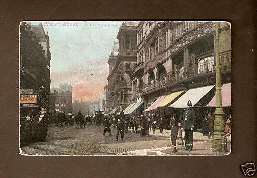
I don't know if that's a corner of St. Peter's peeking through in the gap in the buildings on the left but you can certainly see just how far back off the present street line the altar would be.
1910
Hi JMLE, I think you're right, just in view. Nice image btw.
Bloody hell! Dazza, you?ve done it now.
If Tom Slemen finds out about the location of the arcade in relation to the old churchyard and cemetery, we are going to have ghosts and time warps every other week!
No worries Samp, all the remains were all removed in 1868, and re-interred in Anfield cemetery.
Ahhh....but, all the ghosts and spirits remain WOOoooo!!!.
Thanks for the info'Dazza,but as for the altar,I only repeated the "Myth", as quoted in one of the various Liverpool history books! I can't remember which one,but it looks like they(?) got it wrong! Maybe you should do one?
Thanks wsteve55, the cross over altar is a city myth that's been around for as long as it's been set in the pavement. I just thought I'd cross this one off my list.
A book - well, I never say never? Thanks for the thought...
Daz
I thought I'd add a comparison before and after photo of the church.

 Posting Permissions

 Reply With Quote


Bookmarks