
Do you mean this one with the mature trees partially obscuring it?:Originally Posted by ChrisGeorge

Click to enlarge.


Do you mean this one with the mature trees partially obscuring it?:
I believe it is definatly this location/area and we should leave it at this,Colin it was this area ie ParkWay.This is where I was thinking the action had taken place - the angle is as near as I can get it and the landscape on the left is totally changed, apart from the wall.
Might those be the gates?Actually the gates in question would have been on the back side, i.e., Selborne Street side, right?
What's meant by Davec's comment "Colin, the little lad is smack bang in the middle of the road," -- I don't see that at all.
Any thoughts about the street being paved with stone setts (that some call "cobblestones") rather than asphalted.
Chris
Christopher T. George
Editor, Ripperologist
Editor, Loch Raven Review
http://christophertgeorge.blogspot.com/
Chris on Flickr and on MySpace
Chris,underneath all that asphalt are the original setts;well not always, and it was quite usual to tarmac over rather than uplift the "cobble" roadway. If you expand the photo on post # 23 you will see some remaining setts in the gateway entrance which have never been asphalted over, the continuance of them is under the adjoining roadway.
The B/W insert photo :"the little lad is smack bang in the middle of the road" refers to the positioning of the boy in front of the gate (attached to what??) showing where the housing behind him would have stood prior demolition and the street sign corresponding positions and roadways as marked. As I say the gate in question is the bugbear, unless it was swung out into Shelborne Rd from the entranceway on the left ....... see brick and sandstone pillars at back of Princes Rd Synagogue, post # 23
/
Grekko, yes that's pretty much where I mean.
Chris, looking at Colin's photo I see what looks to me like a curbside on the left and a curbside on the right that are pretty much the same distance from the lad.
This link is to the same overhead view, but allows you to get a decent enlarged view if you click it. If you have a look at Princes Road end of Selbourne Street (just around the corner from the front of the Synagogue) there appears to be something in the road.
What it is I don't know, but it looks like maybe bushes.
http://www.btinternet.com/~m.royden/...ges/aerial.jpg
Chris, hope you managed to make some sense of my muddled explanation.
---------- Post added at 11:46 AM ---------- Previous post was at 11:36 AM ----------
See what you mean Dave, as you say it could be bushes but why in the centre of a roadway like that,unless it was unadopted and privately gated, weird it is, great spot by you though, but we're no more certain than when this started by the looks of it. The original photographer Frank Dugan is no longer with us to explain as he died in 2003 or 4 and his widow died in January of this year so any hope that she may have known of Frank's photo location has gone also.
Hi grecko and Davec
Many thanks for the information. Interesting how Frank Dugan's 1954 photograph continues to intrigue and confound us!
Chris
Christopher T. George
Editor, Ripperologist
Editor, Loch Raven Review
http://christophertgeorge.blogspot.com/
Chris on Flickr and on MySpace
The setts/cobbles were there till at least the mid 60's, I used to go down Park Way to get to Stanley House in Upper Parly.
Re the bogs.........cut and paste from the LRO catalogue;
RefNo 296 OHC/58/4
Title Plan for the proposed urinal in Selbourne Street, Liverpool
Date 1890
Extent 1 paper
First record Previous record Record: 2 of 2
Okay, thanks, Dave
Christopher T. George
Editor, Ripperologist
Editor, Loch Raven Review
http://christophertgeorge.blogspot.com/
Chris on Flickr and on MySpace
My god, another underground urinal, just how many of these are hidden under our streets. I knew of Derby sq, London rd, Victoria St, and Rotunda.....did the Victorians build many of these?
Now I think of it,a photographer taking photo's in a gents toilet
Of course they did...Scotland Rd,West Derby Rd is two others I know of,the vics where very thoughtful when out and about and besides the bogs they also implemented drinking fountains at various locations in liverpool.did the Victorians build many of these?
Nowadays you sometimes have to find a betting shop or pub to have a pee.
Thanks to all the efforts made in locating the photo. I took my camera down to Princes Avenue this afternoon to follow up the location named. Here is my photo of Parkway taken from inside the gateway of the stuccoed terrace opposite. It all seems to fit. I presume that the gates were removed after the photo was taken and also that the central boulevard was remodelled and extended. Otherwise it all seems to fit.
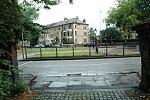
If you look at the overhead map you can see that it is not possible to drive your horse and cart from Princes Avenue to Selbourne street. It actually looks like some sort of private garden.
Regarding the houses in the background of the subject picture, I used to walk along Park Way to get to & from school and I distinctly remember that block being pulled down in the late 70's, possibly around 1977.
If you look at the original photo and at the head of the road leading to the gates you will see a round roadsign either side of the boy on black and white poles. We can only see the back of them obviously but Possibly saying no entry or no motor vehicles as it's private?
Ged, they would be 'no entry' signs, not because it was private, but because to have traffic entering Princes Avenue from the bottom of Selbourne St. would cause havoc.
Colin, I'm afraid that is still not where I believe it to be. That is Park Way where it meets Princes Avenue. I'm suggesting that the photo was taken in Selbournes St. looking towards Park Way.
 Posting Permissions

 Reply With Quote
Bookmarks