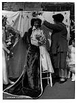
This is another set of photos from LRO looking up from both sides of the bottom of Roscommon - Gt. Homer Street and top of Roscommon St, Netherfield Road area .Fourth pic bears closer examination because -
Click image for larger version. 

Name:	Lee's shoe shop, cnr. Roscommon St-Gt Homer S..jpg 
Views:	1290 
Size:	999.9 KB 
ID:	21994Click image for larger version. 

Name:	Rossy from Gt Homer St (rh).jpg 
Views:	1127 
Size:	2.19 MB 
ID:	21995Click image for larger version. 

Name:	Netherfield Rd curving into the distant St Georges Hill.jpg 
Views:	2159 
Size:	1.67 MB 
ID:	21992Click image for larger version. 

Name:	Netherfield Road N meets Netherfield Road South , showing  St George's Hill.jpg 
Views:	1180 
Size:	1.80 MB 
ID:	21991


A ordinance survey map of the areas of interest showing Upper Roscommon Street And Netherfield Place, both unknown to me before now, map date is 1952 which means I would have been three!
Click image for larger version. 

Name:	Rossy area map--.jpg 
Views:	2004 
Size:	2.43 MB 
ID:	21993

Peeling the 1000 layers of the onion,
Chas

All images supplied by LRO