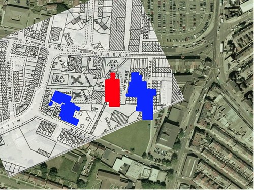
The school, in Blue, on the left, over the burial ground, was built in the late 80's early 90's as the "Old School" on your map, just to the right, wasn't demolished until the mid 80's ( this is the school I went to ) the Junior School.
The School in Blue ( to the right on your map ) is the place in question.
Percival St and the other hosues, along with the Ropers Arms pub, all stood where they are on your map but were demolished late 60's early 70's. The scrubland was where these houses were.
I'm sorry to disappoint you but I was at the school, knew people who lived in the flats ( where Tesco's is ) and could see over the fence, to where they were building.
St. Oswald's Junior School appears on your map just below the church.
St. Oswald's infants School was in what became the Montini Youth club, next to the Wesleyan Chapel ( later St. Oswald's club ) on St. Oswald's st.
I went to both of them up until leaving in 1973.
Then...
The "new" school was started, on the scrubland, where Percival St WAS,
alongside the church in St. Oswalds St.
They then demolished the "Old" school, in montague rd, below the church on your map, then they build the "newer" school", on Montague Rd, next to the burial grounds.
This was the order they done it in.
They have 2 new schools, one built in the 70's and one late 80's.
The one built in the late 70's is the one where the mass graves were found.
Hope this clears things up a bit and we still don't know where they came from


Originally Posted by fortinian

but ....

 Reply With Quote


Bookmarks