Pete E, you are right to be scratching your head... but I have a sneaking suspicion you are right, theat we are looking at the wrong school.
I don't mean to pour doubt on your truthfulness hmtmaj, but childhood memory is a notoriously fickle thing.
If we look at the 1981 Ben Travers article, previously posted there are a few clues that support Pete E...
1. The lead photo seems to show the church some distance from the school... behind quite a lot of trees. Now if you look on the modern googlemap below, you can see where the 'BLUE' school is there are few trees that side of the church. On the other side, where Pete E is speaking about there are many trees and I imagine would give a photo like the one in the article.
But of course, trees can be cut down... so here is some more evidence.
2. Father Patrick James McCartney, parish priest in 1973 is said to have noticed the burials "at the bottom of the garden". We know that the church was surrounded by a graveyard (hardly going to be called a 'garden') and the area where the BLUE school is was already built on... this leads to the conclusion that the priest is talking about the garden to the presbetry, on the rear left hand side of the church and with an extensive garden over the old "Burial Ground (dis.)".
3. The article then goes on to say "three feet beneath St Oswalds scrubland". Hardly what you would call the land where 'Percival Street' was. Scrubland is a weird phrase to use really, on the post-1906 OS map there is an area of trees to the south of the church/presbetry... but would that be scrubland? And even stranger... there was no burial ground marked there...
I suspect that the reporter was getting confused between scrub and garden but still...
The final proof... for me at least is what happens when I map the new Junior School site onto the post-1906 OS map.
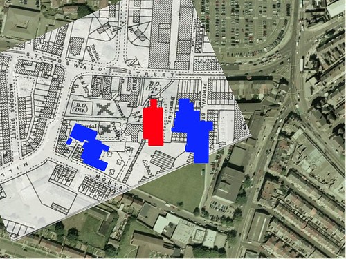
The school building covers half of the disused burial ground.
I've convinced myself... but if anyone has any other ideas or can see flaws in my argument i'd love to hear them.


Originally Posted by fortinian

but ....


 Reply With Quote


Bookmarks