
Yes you are correct. Thanks, AZ.Originally Posted by az_gila

C


Yes you are correct. Thanks, AZ.
C
Christopher T. George
Editor, Ripperologist
Editor, Loch Raven Review
http://christophertgeorge.blogspot.com/
Chris on Flickr and on MySpace
Not just the buses in recent times, either. The tram terminus was there, so it was natural enough for the trams to have that on their destination boards. As a result, by custom and use, the whole area, not just the lane itself and not just Smithdown Place, was known as Penny Lane.
I always understood that it was named after James Penny, though cannot cite sources. It seems likely though that the civic fathers might wish to commemorate his name; I'm pretty sure it's on record that he took up the cudgels against the upstart abolitionists in the city like Rathbone.
It is more likely that rather than 'civic fathers' naming the street after James Penny that Penny owned the land and laid out the street.
A landowner could approach them and say 'i'd like to build a street here on my land, ok?' and the council rarely said no. The council even sometimes asked private men to build streets.
See here for the earliest referece I can find on Parr Street (from 1780):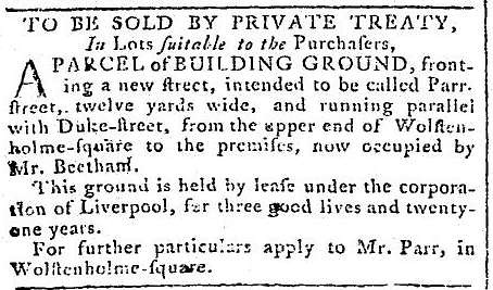
The age of the lease is expressed as 'three good lives and twenty-one years'.
That would cover yourself, your son or daughter, your grandchildren, and your great-grandchildren....but only up to their 21st birthday!
"I have never let my schooling interfere with my education."... ... ... Mark Twain.
I wonder... what's the earliest map that shows the thoroughfare as "Penny Lane"? I would trust Taffy, as a local expert, to know if it the road was definitely named for James Penny but he has indicated that he doesn't have information to that effect. As I recall, the housing on Penny Lane is probably Victorian, as is the railway bridge. Before the coming of the railways it was likely to have been a country lane... was it called Penny Lane back then or something else?
Chris
Christopher T. George
Editor, Ripperologist
Editor, Loch Raven Review
http://christophertgeorge.blogspot.com/
Chris on Flickr and on MySpace
I can confirm that 'Penny Lane' is recorded on the Lancashire & Furness map of 1850/51.
Properties called 'Oakfield, 'Grove House' and 'Grove Cottage' are the only housing indicated. The railway, and railway bridge are also indicated. The rest is farmland.
I can't publish the map here, as it's copywrite protected.
"I have never let my schooling interfere with my education."... ... ... Mark Twain.
For some reason 'Three Good Lives and Twenty-One Years' was the standard Liverpool lease. Other towns had their own particular standards.
Penny "Lane" suggests that it was not intended by Penny to be a residential street when it was named. Lanes tend to be thoroughfares in the most literal sense of the word. For instance Cromptons Lane was named after Peter Crompton who owned Eton House (nowadays Bishop Eton). It was the lane that led to his dwelling.
Penny lane must have been named before 1800 as James Penny died circa 1799.
Was it ever defined numerically what 'Three Good Lives and Twenty-One Years' amounted to? Or was that not the point here? As lives are variable, so to are the leases?
Do we know the name of Penny's house?
"I have never let my schooling interfere with my education."... ... ... Mark Twain.
I think (although I do not have the book I read it in to hand) that they used the biblical 'threescore and ten' to mean a lifetime. That would be about 70 years perhaps? So altogether that would be 231 years I think.
Penny lived in numerous places, but I can't find any reference to a mansion house as such. Towards the end of his life I think he was living at Mount Pleasant.
Very interesting, thanks. There must have been a shift between thinking in terms of natural cycles - sunrise, sunset, life and death, three good lives [and 21 years] and increased use of linear abstractions...numbers and clock-time. The day's measured. Noon in Liverpool was always different than noon in London, until the railways regularised them. I guess the shift from agriculture to industry in the cities.
Penny - ok thanks.
"I have never let my schooling interfere with my education."... ... ... Mark Twain.
Information from the Liverpool Record Office and Local History Service places James Penny at a number of downtown locations:
"James Penny is listed in the available Gore's Directory of Liverpool for the period as follows:
1772, 1773 Capt. Penny, Church Street
1774 Captain Penny No. 18, Old Church Yard
1777 Capt. James Penny, 18 Church Street
1781 James Penny, merchant
1787 James Penny, merchant, Ranelagh Street
1790 James Penny, merchant, Hope Street, Martindale Hill
1796 James Penny, merchant, 2 Hope Street, Mount Pleasant Street
James Penny, Junior, merchant, is also listed at this last address."
He appears to have come originally from Ulverston in the Lake District. The family appears to have retained connections to the Ulverston area as well.
"The burial register of St. James, Toxteth, 1790-1799, gives the date of death for 'James Penny, Mercht. Agd. 58 yrs' as 26th August 1799 and the date of burial as 29th August. James Gibson Epitaphs... in Liverpool Churches..., Vol. 3, p. 201, gives his date of death as 27th August 1799 and the death of his eldest son, James, as 7th August 1820, aged 47 years."
Conceivably it is this Toxteth connection that might imply a link with Penny Lane, the land where Penny Lane is located (running from Greenbank Road to Smithdown Place) being, I should think, within the limits of Toxteth Park. That might imply that Penny Lane might owe its name to his son rather than the Liverpool merchant involved in the slave trade, and who for defending that trade was honored by the Corporation of Liverpool. The other alternative might be that, if the thoroughfare is indeed named for the merchant, someone named it after him because of his work as an anti-abolitionist.
If it is not possible to establish a link between James Penny and Penny Lane, could it be that the connection is more traditional rather than factual, i.e., just be a coincidence of names? What's the true story?
In his Street Names of Liverpool (Countryvise Press, 2002), Steve Horton evidently does not feel comfortable enough to attribute the name "Penny Lane" to a connection with merchant James Penny as he does with other such streets such as Bold Street, Bold Place, and Tarleton Street which have clear connections to families involved in the African trade, as he discusses on pp. 9-11 of his book in a section entitled "The Slave Traders of Liverpool".
By contrast, he does attribute Greenbank Drive, Greenbank Lane, Greenbank Road as well as Rathbone Road in Wavertree to their origin with the anti-slavery Rathbone family whose mansion was Greenbank House, ironically (though the author doesn't say it!) located near the western end of Penny Lane, in a section titled "Liverpool's Slavery Abolitionists" on p. 12 of the book.
Chris
Christopher T. George
Editor, Ripperologist
Editor, Loch Raven Review
http://christophertgeorge.blogspot.com/
Chris on Flickr and on MySpace
Are you sure it included the great grandchildren as wouldn't that be four good lives (if your own was counted)?
Very perceptive and thorough CG. Penny Lane could have been named after Pennys death by his son... or indeed named after his son. For example:
Lots of people will tell you that Edward Falkner laid out Falkner Square and named it after himself. He certainly began building the square and wanted to name it Waterloo Square but he died half way through building, so his son (confusingly) Edward Deane Falkner completed it and asked the town council if he could re-name it in honour of his late father.
This line, from a poem, is inscribed in wood at the site of St Thomas' Church, Park Lane:
"Penny Lane, Slavery Shame"
The poem has several other 'witty' rhymes about Liverpool life.
Hi Fortinian
As you say, Penny Lane, if it is named for a member of the Penny family, might not be named for the merchant but for his son, as per the example of Falkner Square being named for the son of Edward Falkner and not the father as many assume.
I do note that the lane, though undesignated, appears on the 1765 map of Toxteth Park listed as being in the possession of the Earl of Sefton in Robert Griffiths' History of the Royal and Ancient Park of Toxteth (1907) on pages 14-15 though in very miniscule detail making it hard to make out the wording. At that time, there were just fields on either side of the road, one of them on the northwest side of the road midway between Greenbank Road and Smithdown Place being labeled "Dove Hey" I discovered on enlarging the map -- presumably the origin of the name "Dovedale Road". A similar map of about the same time can be seen opposite page 112 in Ramsay Muir's A History of Liverpool (1907) available on Google Books.
Chris
---------- Post added at 02:45 PM ---------- Previous post was at 02:42 PM ----------
Thanks, Marky. I assume that the poem is recent though, not old, is that right?
Chris
Christopher T. George
Editor, Ripperologist
Editor, Loch Raven Review
http://christophertgeorge.blogspot.com/
Chris on Flickr and on MySpace
 Posting Permissions

 Reply With Quote
Bookmarks