Another Burrow's 6th edition 1960's pointer map..
And my Liverpool Old Ordnance survey maps.

Another Burrow's 6th edition 1960's pointer map..
And my Liverpool Old Ordnance survey maps.
Originally Posted by MerseysideTransportTrust

Yes please, Rob.
I'd love to see more.
It's great to see them in colour.
I've photocopied loads from the library, but all in B & W.

Ok Philip
I'll start a new thread and get them on a bit at a time.
Regards
Rob
Well done Rob, there,s probably loads of us waiting to get a blimp of them
My Dad was born in Kitchen Street
The new Amsterdam at Liverpool?
Save Liverpool Docks and Waterways - Click
Deprived of its unique dockland waters Liverpool
becomes a Venice without canals, just another city, no
longer of special interest to anyone, least of all the
tourist. Would we visit a modernised Venice of filled in
canals to view its modern museum describing
how it once was?
Giving Liverpool a full Metro - CLICK
Rapid-transit rail: Everton, Liverpool & Arena - CLICK
Save Royal Iris - Sign Petition

The Flag company was in that street. When I was about 16 I went there for a job interview.
My great grandfather was the residential stable master at Walker's Ales stables on Kitchen Street circa 1910-1930 and a great uncle followed him from about 1930 -35.
The stables building is sadly demolished now and the plot stands vacant and tatty. A McDonald's has been built on the Dock Rd frontage and truncates the Kitchen St and Bridgwater St junctions.
There's a short piece on the stables (and some nice drawings of the facade and interior) in a Walker's Ales 1896 golden jubilee souvenir book. I've been trying to attach an extract but unfortunately the upload function keeps failing.
Anyway, I'm keen to know if there's any more information available (I couldn't find anything at the public records office where Walker's archives are deposited). If anyone here can point me to further information I'd be very grateful.
Regards,
WB.
I took this a few days ago (for the large warehouse between Blundell and Kitchen Streets), but from your description, this sounds the area you're interested in. Maybe It'll jog someones memory.
http://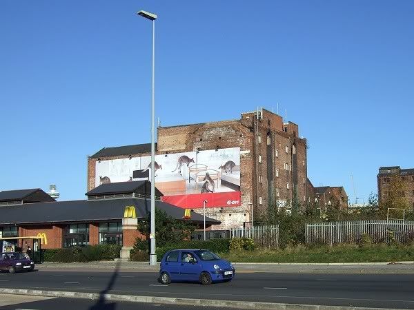
Yes, that's right Marky. The Walkers stables would have been in the overgrown land behind the pallisade fence on the right hand side of your photo. Thanks for taking and posting this.
Just had another go at uploading the scanned book extract but sadly no joy. (gif reduced in size to 208kb, 728 x 530pixels - any ideas what I might be doing wrong?)
Cheers,
WB.
Hi,
Apologies if this is Off topic.
Bennison's Map of Liverpool was published in 1835. It covers most of modern day Liverpool, from Seaforth and Aintree in the north, Fazakerley and West Derby to the east, down to Allerton, Childwall and Woolton in the south.
The northern section of the map is on my website, and I'm hoping to get the remainder online before Christmas. Here is a sample, covering Bootle.
See you,
Tony
Last edited by TonyS; 12-27-2007 at 07:26 PM. Reason: Accidentally deleted images.
Fantastic maps! if you anything on Edge Hill and Childwall, I'd be more than grateful for a nose!!
Hi,
This is a section of Bennison's 1835 Map of Liverpool, covering the Chidwall area. The sheets covering Much Woolton, Allerton, Mossley Hill and Aigburth, as well as those covering north Liverpool, are now online.
See you,
Tony
An ice cold PINT for Tony! Excellent Maps there - would you give me permission for me to use them on my www.childwall.info website?
Many old Liverpool maps, courtesy LRO:
1- Boundaries
2- 19th Century Liverpool
3- 1644 including Liverpool Castle
4- Everton 1716
5- 1725 Liverpool 'Town'
6- 1765 JOHN EYES MAP OF LIVERPOOL
7- 1765 JOHN EYES MAP OF OLD DOCK AND SOUTH DOCK
8- 1769 MAP OF CHILDWALL [FOR BRO CAD]
9- 1769 MAP OF WALTON AND BRECK ROAD
10- 1769 MAP OF EVERTON AND DOCKS
11- 1795 Plan of Liverpool
12- 1796 John Gere plan of Liverpool
13- 1835 Map of the town of Liverpool and parts of Liverpool (northeast)
14- 1849 Cholera Map
15- 1849 MAP OF THE CITY SUPERIMPOSED WITH DISTANCE TO BE MEASURED FOR HACKNEY CARRIAGES
16- 1858 Map of Vauxhall
17- 1908 MAP OF UNHEALTHY AREAS FOR PROVISION UNDER THE HOUSING OF THE WORKING CLASSES ACT1890
18- 1909 Medical offices map of insanitary areas in Liverpool
19- HISTORICAL MAP OF LIVERPOOL 1664
20- JOHN EYRES 1765 MAP OF LIVERPOOL
21- Map of Liverpool 1797 - High Water
Enjoy......
Become A Supporter 👇
Donate Via PayPal

1- OS 25 map section of Eldon Street and area 1893. Shows Eldon Street before Brodie's concrete flats - site is the courts between school and Vauxhall Road.
2- OS 25 map section of Eldon Street and area 1908. Shows Eldon Street after Brodie's concrete flats built - see change from previous attachment.
3- OS 25 map section of Eldon Street and area 1927. Shows continuing change in Eldon Street area. (NB new flats in Bevington Street)
4- OS 120 map showing part of Eldon Street 1891. The section shows courts 2 and 4 which were demolished to make way for Brodie's concrete flats.
Become A Supporter 👇
Donate Via PayPal
 Posting Permissions


 Reply With Quote


Bookmarks