
Very interesting! Thanks again, Marky!Originally Posted by marky

Chris


Very interesting! Thanks again, Marky!
Chris
Christopher T. George
Editor, Ripperologist
Editor, Loch Raven Review
http://christophertgeorge.blogspot.com/
Chris on Flickr and on MySpace
Garston/Speke Boundary Stone?
Banks Road/Speke Road (over the road from the old fire-station, which has now been converted to flats), have a look on the grass verge...near to the sign for 'Speke'
I don't know for certain, but it is in the right place to be a boundary marker (I'd have to see some reference to it on a map, or have it confirmed by someone who knows the area better).
Last edited by marky; 03-11-2007 at 12:48 AM.
Smithdown Road...I think this is another Railway Boundary Post, but it has no markings at all. The other one (just around the corner) is marked as a Boundary Post, but is off the pathway and so is in good condition. I suspect this one is worn away because of pedestrians.
This metal plate is shown bottom-right on the second picture (together with a quirk...all colours of one set of traffic lights are still lit)
Hi Taffy
You could be right. My first reaction was that it was the remains of a gatepost or maybe a hitching post but is that some lettering on top of it?
Chris
Christopher T. George
Editor, Ripperologist
Editor, Loch Raven Review
http://christophertgeorge.blogspot.com/
Chris on Flickr and on MySpace
Riversdale Road. If anyone's got an old map, then this might appear. It has all the correct features of a boundary stone, but doesn't have any markings.
Nice find Marky. I cannot see a Boundary Stone marked on Riversdale Rd on the 1905 OS map. There are two bench marks shown. Could this post have held a metal bench mark plate. Where precisely is the stone you found?
It's a shame if it isn't as it looks similar to some others (natural stone, gravestone shape). I did wonder what the strange impression was on the front, as if it held something or it was butted up against something.
As you head down from Aigburth Road it is about half-way down on the left (a little bit before you hit the present-day footpath on the left)
a Wavertree township marker on Binns Road

My nan used to live in the house next door to the builders merchants on Wavertree High Street, now my mind may be playing tricks with me (it was a good 15-20 years or so ago) but I'm fairly certain there is a boundary stone marker in the wall the separates the house garden to that of Wayne/Village builders merchants.
As I said, could be mistaken though as I was a kid at the time I just seem to remember being told about it.
Last edited by Bendo; 05-31-2007 at 12:33 AM.
Spotted this one on Allerton Rd, Allerton. Must have passed this a 1000 times and not seen it before. It looks like some sort of crown boundary marker possibly related to the Allerton Police Station Boundary.
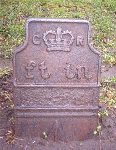
Here's another one of those metal plates...Greenhill Road/Brodie Avenue (at the bottom of the railway bridge). This looks to be identical...a GR Crown and Feet and Inches measurements. I don't know what they mark, but they are rare.
Very interesting, Taffy and Marky. I am almost tempted to think that the style of the crown and the type of lettering might date back to George III but that hardly seems possible, so I suppose it must be George V or VI.
Chris
Christopher T. George
Editor, Ripperologist
Editor, Loch Raven Review
http://christophertgeorge.blogspot.com/
Chris on Flickr and on MySpace
The G R does indeed refer to George V as he wouldn't have been confused with the previous King George who died in 1830. His son George had to use the VI after his name though to avoid confusion with his father.
The 'G R Ft in' plates above are ordinance survey benchmarks and the benchmark symbolwill be hidden below pavement level and should look like this one -
The groove above the arrow is to insert the measuring tool and can be seen carved into stone also as we have seen on the Thingwall/Knotty Ash sandstone marker post.
Last edited by MarkA; 06-13-2007 at 09:51 AM.
Great information. Thank you so much, Mark.
Chris
Christopher T. George
Editor, Ripperologist
Editor, Loch Raven Review
http://christophertgeorge.blogspot.com/
Chris on Flickr and on MySpace
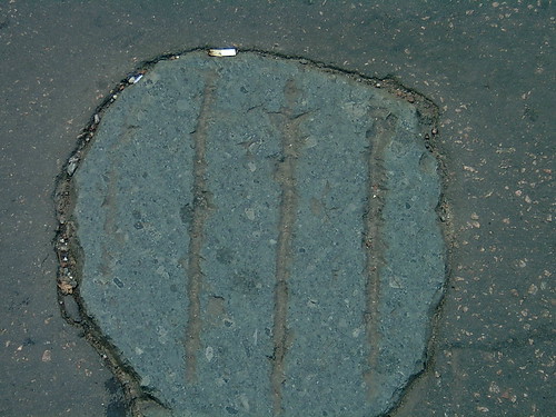
In Castle Street, in the northbound lane about 100 yards south of the Town Hall. . .
Christopher T. George
Editor, Ripperologist
Editor, Loch Raven Review
http://christophertgeorge.blogspot.com/
Chris on Flickr and on MySpace
 Posting Permissions

 Reply With Quote
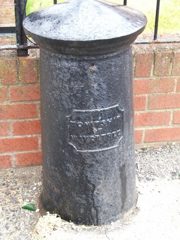

Bookmarks